Storm Chase Details
Chase Date: May 17, 2008
Miles Logged: 70
States Chased: MI
Spotter Network Reports: 3
-
Wind 2 NE Riley, MI
×
Wind 2 NE Riley, MI
Timestamp: May 17, 2008, 5:04 PM CDT
Latitude: 42.9329796
Longitude: -84.6412888
NWS Office: Grand Rapids, MI
Narrative: Approximately 45 mph gust
Wind Speed: 45 mph
-
Other 4 S Saint Johns, MI
×
Other 4 S Saint Johns, MI
Timestamp: May 17, 2008, 5:16 PM CDT
Latitude: 42.9503708
Longitude: -84.5703583
NWS Office: Grand Rapids, MI
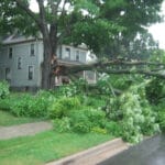
Narrative: Large Tree down across road.
Damage: Yes
-
Other 4 W Price, MI
×
Other 4 W Price, MI
Timestamp: May 17, 2008, 5:39 PM CDT
Latitude: 42.929039
Longitude: -84.5544662
NWS Office: Grand Rapids, MI
Narrative: Large tree down approximately 2 feet in diameter. Healthy
Damage: Yes
Severe Risks: SPC OutlooksSevere Reports: Storm Reports
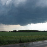
Quick surprise chase for some severe warned storms in Clinton County Michigan. Produced some tree damage.


